 The “Red Book” is the set of municipal design guidelines that HRM uses when building streets, sidewalks, and more.
This book specifies the rules for how something should be built, and not why it should be built. It will talk about the dimensions of a sign, but not the justification for a sign to be placed or removed. The rules about why fall within the traffic division and in a lot of cases is left to the experts in that field.
The Red Book helps us issue tenders so that everyone knows what to expect; vendors can bid on a level playing field; and we can evaluate and confirm their work more easily.
Every few years the red book is updated to incorporate the latest improvements in technology and the street structure. The Red Book was last released in 2013, and is nearing the end of another review cycle.
The Red Book page on the HRM web site is here: https://www.halifax.ca/transportation/streets-sidewalks/municipal-design-guidelines-red-book.
The report that we recently saw at Council is here: https://www.halifax.ca/sites/default/files/documents/city-hall/regional-council/210629rc11111.pdf
Each of these three large documents has been broken down to the documents are in this table:
I’ve been keeping an eye out for issues for the past while, related to the challenges with the 2013 Red Book, but I’m only one person. I need your help. What’s missing in the 2021 version? What do you like? What could be improved?
The list of things that I’ve seen or have heard about is below, and mostly comes from the first of these three books.
If you have questions or would like to see anything added to this list then please let me know. We will be reviewing this book, as Council, in the coming months.
Page 11 of the Design Guidelines states: "
The Municipality is working on updating street classifications for new and existing streets to create more diverse design guidelines based on adjacent land use and intended street function in the network for various modes."?
Will those street classifications amend what's in the Red Book?
When is this work expected to be completed?
Table 2.8 in the Design Guidelines discusses different designations of streets. Some of these are Suburban and some are Rural.
We have different definitions of the areas that are Suburban or Rural, and this is confusing enough.
Which definition is being used here? Is it related to the regional water boundary, the property tax mapping, or a different map?
Riverside Drive is a raceway. It's categorized as a minor collector that is 9 metres wide. On that street I've seen cars that have vastly exceeded the speed limit and have driven in excess of 80 kmh, and there have been multiple convictions because of stunting. A few weeks ago there were three collisions in one day, and most of them were related to speed.
Midnight Run, in District 16, has also been described as a raceway. It also has 9 metre wide streets and long strait stretches. Multiple residents have reported speeding there, and I have data to confirm their claims. This is a new street, and according to our GIS it doesn't have a designation yet so it's hard to tell, but residents are already asking for traffic calming.
Riverside Drive is a minor collector and is 9 metres wide, and Beaver Bank Road is an arterial and is, in some cases, 8.5 metres wide.
We can't continue the practice of building raceways and calling them residential streets.
Page 18 of the Standard Details (2021) document shows a Suburban Minor Collector. I chose this because it might match what we have on Riverside Drive - if Riverside Drive is within the Suburban boundary.
This shows that the street width will be from 8.0 to 11.6 metres wide, and that it will accommodate 3 lanes of traffic that are 3.0 to 3.7 metres wide.
- Will all suburban minor collectors be designed to accommodate 3 lanes of traffic?
- With a minimum width of 3.0 metres, for each of the three lanes, doesn't that mean that they will all continue to be at least 9.0 metres wide?
Page 35 of the Standard Details shows speed humps, and that the maximum height is 3" over a 4 metre width. This is the same geometry that we've seen on some streets recently including Cavalier Drive and Hillside Drive. The observations from nearby residents is that this height does nothing to slow cars down. I can confirm that you can drive over those speed humps, at the speed limit, and have absolutely no concern.
The geometry of the speed humps doesn't work to slow traffic down. Either the design of them needs to be reconsidered, or their use for traffic calming needs to be reconsidered.
Page 53 of the Standard Details shows a wide turn on a corner and page 138 shows a tactile walking surface on a wide corner.
At the Accessibility Advisory Committee we recently received a presentation that these types of corners are fine for fully able pedestrians who are able to see and jump out of the way, but they are also great for vehicles. There is no obstruction for vehicles, and so we heard that they will often cut the corner and drive over the tactile walking surface. This makes these types of corners especially dangerous for anyone who is not fully able and is not able to jump out of the way.
 Driveway and curb cut-through diagrams are in HRM-32, HRM-50, and HRM-51. All of these are drawn as if the driveway is above grade, which is usually the case where there are sidewalks. There are no examples where the driveway is below grade, as is often the case when there are no sidewalks.
In these situations, where the driveway is below the street grade, we need to consider the flow of water from the street on to the adjacent property, and how to mitigate that.
The two solutions that we've seen are:
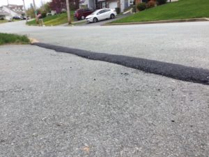
a) an asphalt bump along the street line, so that water doesn't flow on to the property; and
b) a grate along the street line, so that water connects with the stormwater system.
The asphalt bump is cheaper and easier to install, but it can cause an ice dam. The grate along the street would be more expensive because it requires opening more of the street and connecting to the stormwater system.
We should standardize on when these two systems are used.
I didn't see any standards for medians. If they aren't contained in the Red Book then where are they contained?
Sucker Brook Road is one entrance to the First Lake trail system. People regularly drive to the end of the road and park perpendicular to the flow of traffic. This is a system that works well, in this case, and should be continued.
There is no provision, in the Red Book, for the design of on street parking, whether it is in line with the traffic flow, angled, or perpendicular. This should be added.
Over the years we've seen multiple designs for roundabouts. Some are two lanes wide, and some are one lane wide. Some are called a rotary and some are called a roundabout. We have design concerns with many of them. Unfortunately we haven't seen any design standards, in these books, related to roundabouts.
It takes a lot of effort to widen a road or move a house, let alone a whole block of houses, so either an alternative is found or we simply accept the state of the road.
Planning is one of the most significant activities that Council does. This is another one. If we don’t get the rules of road building right then it could affect things decades in to the future.
Please help us get this one right.
 The “Red Book” is the set of municipal design guidelines that HRM uses when building streets, sidewalks, and more.
 Driveway and curb cut-through diagrams are in HRM-32, HRM-50, and HRM-51. All of these are drawn as if the driveway is above grade, which is usually the case where there are sidewalks. There are no examples where the driveway is below grade, as is often the case when there are no sidewalks.